Tumbledown Dick Trail links the Appalachian Trail (AT) with Leavitt Pond and the Turtle Ridge trail system, providing access to scenic falls and to campsites at Tumbledown Dick and Leavitt Ponds. Through this connection, backpackers can tie together trips using over 30 miles of interconnected hiking trails and short sections of gravel roads.
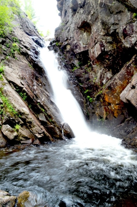
The highlight of the trail is Tumbledown Dick Falls, a narrow drop splashing into a beautiful pool. This feature is found approximately 3 miles from the (southern) Jo Mary Road trailhead. Alternately, the falls are approximately 2 miles southeast of the AT trail head on Nahmakanta Stream Road. This route from the north heading to the falls uses one mile of the Appalachian Trail along Nahmakanta Stream before turning southwards. Expect to briefly follow an old road and cross one newer (2004) forest management road prior to reaching the falls.
If coming from the south, hikers will know they are near the falls when they cross a forest management road and bridge. Cross the bridge to pick the trail up and continue to the falls. Short side trails lead to viewpoints above and below the falls.
Leavitt Pond is reached within a quarter-mile after heading north from the Jo Mary trail head. A little further, near the north shore of the pond, there is a side trail to a primitive campsite (requiring a fire permit from the Maine Forest Service). Between Leavitt Pond and Tumbledown Dick Pond, the trail passes through a stretch of previously harvested forest that is regenerating. North of Tumbledown Dick Pond, the trail follows Tumbledown Dick Stream through mixed woods. Camping is also available at a fire permit only campsite on the west shore of Tumbledown Dick Pond.
All along the length of trail, the terrain is relatively flat, with minor ups and downs. The trail tread is not well defined, but the trail is recently blazed with blue blazes. Expect roots, rocks, and all the other elements of primitive hiking trails.
View BPL's map of the Namakanta Public Reserve Lands.
Visitors must pay day-use fees at the Jo-Mary Gate between April and November, season passes are available from North Maine Woods.
The Maine Division of Parks and Public Lands maintains 5 authorized campsites with privies on Wadleigh Pond, 2 near Musquash Brook, and 2 on Pollywog Pond. On lands owned by the National Park Service bordering Nahmakanta Lake, there are six authorized sites where campfires are permitted. Fire permits are needed for the primitive, traditional campsites on SingSing and Rabbit Ponds as well as the sites at Pollywog Pond, Leavitt Pond, and Tumbledown Dick Pond.
Of the 22 campsites, 10 are drive-to, 9 are boat-to, and 3 are walk-to. There is a hand-carry boat launch at Fourth Debsconeag Lake (with 6 parking spots at most).

This trail passes through a property that was acquired in part with funds from the Land for Maine’s Future program. For more information about the LMF program and the places it has helped to protect, please visit the LMF webpage.
Visit Maine Bureau of Parks and Lands online for more information and a printable map or contact:
![]()
To Nahmakanta Public Lands: From southern Maine, travel beyond Greenville about 1.5 hours (primarily over gravel roads). Drive northeast 15 miles to Kokadjo: reset your odometer at the outlet bridge over the Roach River at First Roach Pond (near the Kokadjo General Store). Reset your odometer at each subsequent intersection as there are many logging roads and follow signs for Nahmakanta Lake Camps and Debsconeag Lakes Wilderness Camps to help guide you. Bear left at 0.3 miles, and follow Sias Hill Road (also known as Kokadjo-Ripogenus Dam Rd.). Go another 1.7 mile, turn right onto Smithtown Rd. Bear right at 3.2 miles, then turn left after a total of 4.9 miles on the Smithtown Rd. This left takes you onto the Farrar Mountain Rd. In 4 miles, bear right and after 1 mile take a hard left. After another 1.8 miles, take a hard right. Bear left after 0.6 miles (use caution – approved ATV use begins on this road). Pass Penobscot Pond with camps on right, and reach boundary sign in another 1.4 mi.
From Brownville, leave Route 11 at the Jo-Mary Campground sign about half way between Brownville Junction and Millinocket (visitors must pay day-use fees at the Jo-Mary Gate between April and November; season passes are available from North Maine Woods). Proceed past the gate and take a right turn in 6 miles. The southern boundary of Nahmakanta Public Lands is 9 more miles in, just after the Henderson automated checkpoint.
Trailheads: The southern trailhead (which is shared with the Turtle Ridge Trail) is located a little over 1.5 miles north of the Henderson Checkpoint on the Jo Mary Rd., in the southeastern corner of the Public Lands. The start of the trail is marked with double blue blazes and is located 150 yards North of the Turtle Ridge Loop East Trail Head on the Jo-Mary Rd.
The trail can also be reached by parking at the Appalachian Trail trail head at Nahmakanta Stream. This small parking area is reached via the Jo-Mary Road (from the southeast or the Nahmaknata Road (from the southwest) to the Wadleigh Pond Road to Nahmakanta Stream Road.
Success! A new password has been emailed to you.